The Flat Earth
The Beatus Map or Beatine Map is one of the most significant cartographic works of the European Early Middle Ages: It was originally drawn by the Spanish monk Beatus of Liébana, based on… Continue reading

The Beatus Map or Beatine Map is one of the most significant cartographic works of the European Early Middle Ages: It was originally drawn by the Spanish monk Beatus of Liébana, based on… Continue reading
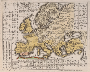
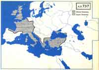
Europe, 1701-1714. The death of King Charles II provoked a succession conflict that gave rise to the war of Succession (1701-1714), where the main European powers took part: France in defence of the… Continue reading
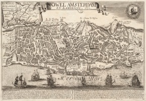
This is a fake: One of the earliest European attempts to publish a view of a North American city from a birds eye perspective is this image titled New Amsterdam. Issued in 1672… Continue reading
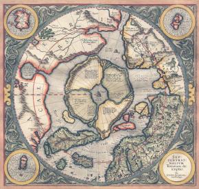
This is a story really wrapped up. Beginning with his origins, to the innomenables copies, cuts, additions, secrets, discussions. All the ingredients for a good novel. The map was discovered in a… Continue reading
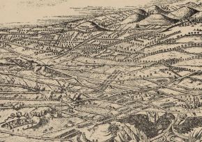
The great work Cosmographie universelle Guillaume Le Testu (or Guillaume Le Têtu) (c. 1509-12 – April 29, 1573), was a French privateer, explorer and navigator. He was one of the foremost cartographers of… Continue reading
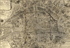
De Fer was so successful at improving the firm that, in 1690, he became the official geographer to Louis, Dauphin of France. With support from the Spanish and French royal families, de Fer… Continue reading
Author Gottfried Hensel (1687-1767) was a German scholar of linguistics working in Hirschberg in Lower Silesia (now southwestern Poland). The title of his work translates to something like Compendium of universal philology, in… Continue reading
The Atlas of True Names is a divertimento of Stephan Hormes and Silke Peust, who plays with the etymological roots and meanings of the original names on the maps of the world today.… Continue reading
The Catalan Atlas is the finest work to come from the Majorcan cartographic school of the fourteenth century. Most probably produced in 1375 (the date that appears on the perpetual calendar accompanying the… Continue reading
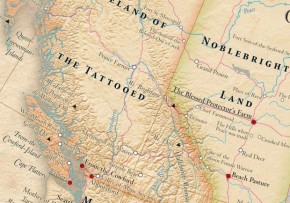
We can start here: We are geniuses inventing fantasies. We have examples of this throughout history. I propose to visit places that have arisen from people’s imagination. We can develop and create new… Continue reading
CANADIAN GEOGRAPHICS From Canada we get these spectacular maps: Canadian Geographics (The Royal Canadian Geographical Society) Historical expeditions to locate the Nile Fountain, published in the March-April 2018 issue. Map: Chris Brackley /… Continue reading
The following maps were created based on the data from the Dodecad Project, Eurogenes, and 23andMe. Please be aware that the maps are very approximate due to the scantity of regional data available,… Continue reading
A recent study by the University of Oxford, says that much of the UK population directly descended from a group of Iberian fishermen who traveled by sea to the British Isles about 6,000… Continue reading
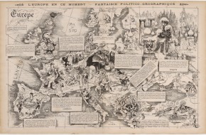
1872 Europe right now. Political-Geographic Fantasy Author: Louis Ernest “Sahib” Lesage and Yves & Barret After the Franco-Prussian war, France, defeated, had lost Alsace and part of Lorraine; and the abolition of the… Continue reading
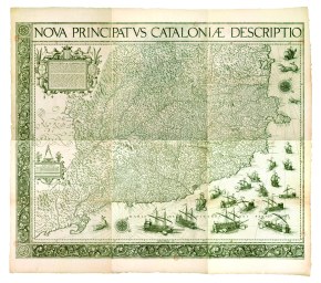
The existence of a quite remarkable wall map of Catalonia, of which only one copy survives, came to light a few decades ago. The map was printed in Antwerp, on six sheets, by… Continue reading
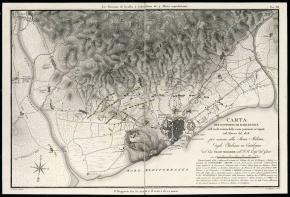
The attempted reconquest of Barcelona by Spanish troops during the Peninsular War, was resolved in favour of French and Italian, who had surrounded the city of trenches. The Division of General Joseph Chabran… Continue reading
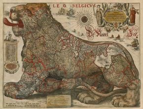
The first Leo Belgicus were made by the Austrian cartographer Michael Aitzinger in 1583, when the Netherlands was struggling for independence. Inspired by the heraldic figure of the lion, which appears on the… Continue reading
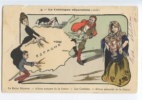
IT WAS INEVITABLE The relations between the Monarchy and the Catalan institutions have reached an extremely critical. The political disputes, tax, legal and ideological crawling long have derived a phase of open confrontation.… Continue reading
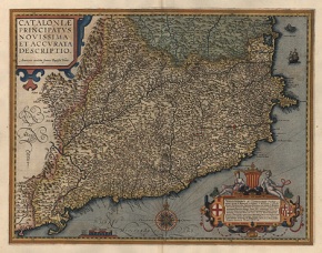
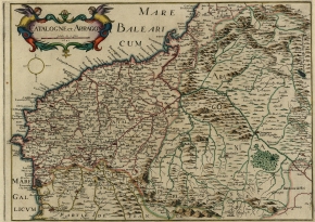
Ioannem Baptistam Vrients (1552-1612) Anvers 1605 101×123 cm The only known specimen of this map of Catalonia – the oldest of those preserved – is in the Bibliothèque Nationale de France. According to… Continue reading
This postcard is 102 years old. No comments. You can find it at ebay.
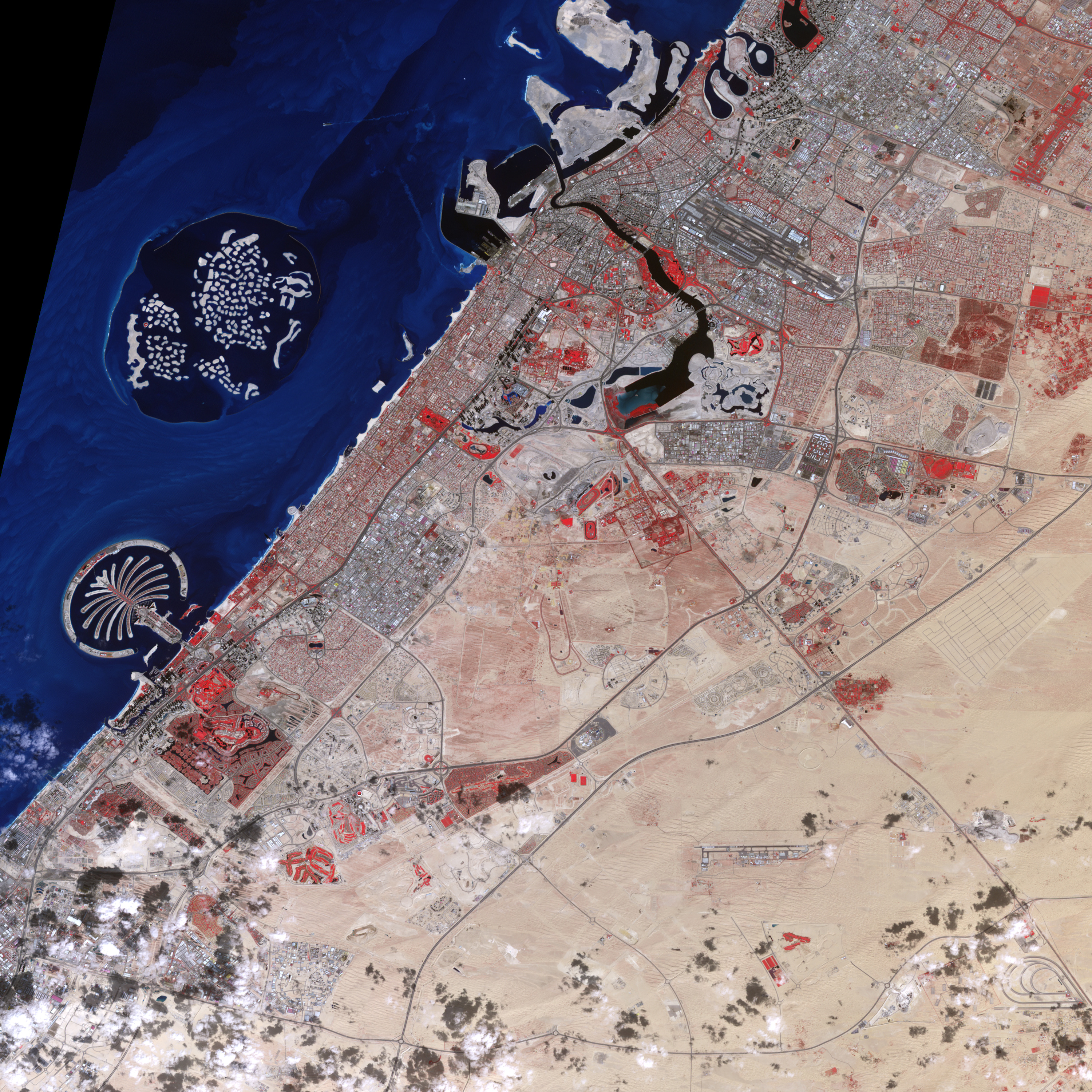
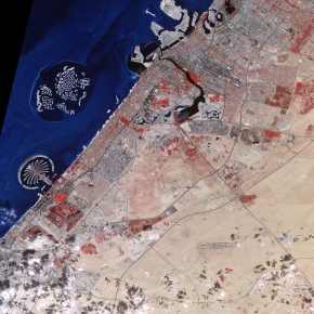
Dubai
I have recently read a few nonsense about the Catalans (newcomers or not) who have left me frozen (not because of the novelty). Now I will not comment. I’d rather see the world… Continue reading
I think the poor man was bored as a retiree. Mr Heineken made the last beer looking at Europe in the green color of his business, and, protected by two historians, saw a… Continue reading
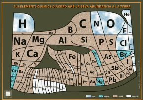
THE PERIODIC TABLE AS A WORLD MAP OF CHEMISTRY. Periodic table according to their abundance on Earth. Girona Periodic Table, a design that has been promoted by the Department of Chemistry with a… Continue reading
These are things that are piled on either side of the table without knowing where (far away) to send it on vacation. I also don’t have a tailor’s drawer. I also have no… Continue reading
For fanatical, casual or sporadic travelers, a little help with this map: Here you can download the Pdf For more adventurous or curious but short-time travelers, the map of Kensington and Chelsea: Here… Continue reading
The blue blood, and other indeterminate color, occupy their leisure time riding profitable businesses. Entertain themselves with dangerous toys. Or exterminated nations, whole peoples or ethnic groups, from Louis XIV to Philip V.… Continue reading
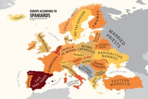
Alphadesigner Blog An opinion found in the comments, very accurate: Having just moved to Spain a few weeks ago, I have also discovered that ‘ahora’ does not really mean ‘now’ as I had… Continue reading
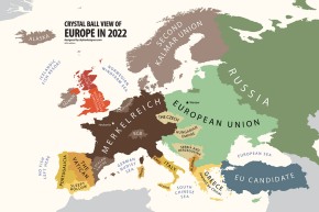
Read on Alphadesigner blog: …The current Eurozone will shrink to a federation-like entity called Merkelreich and will include Germany, France, Austria and Luxembourg. Italy, Spain and Belgium will split into different smaller countries,… Continue reading
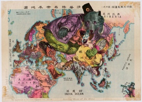
This world, in fact, is a tapestry. A tapestry brilliant, imaginative, a little child. Another way to see the Earth hanging in the dining room instead of a boring couple of deer. Maybe… Continue reading
This is the new image of the London Underground. Comes directly from Transport for London. As a no-commercial version is signed by Mr. Sample. Looking for Olympic athletes … And another curiosity, the… Continue reading
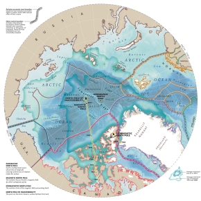
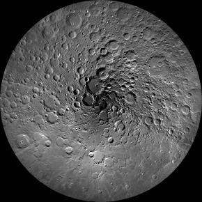
The North Pole of the Moon The Moon has been an inexhaustible source of fascination for humanity for thousands of years. When Apollo 11 finally landed on the surface of the Moon in… Continue reading
The story or how to tell it with four pictures and two words. •OUR IMMEDIATE ANCESTORS. You ask, how the hell did it all begin with Catalonia and the Catalans, who are the… Continue reading
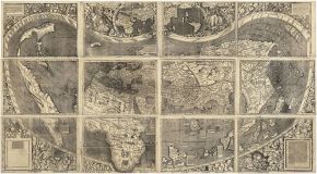
In late May 2003, the Library of Congress completed the purchase of the only surviving copy of the first image of the silhouette of continents of the world as we know it today,… Continue reading
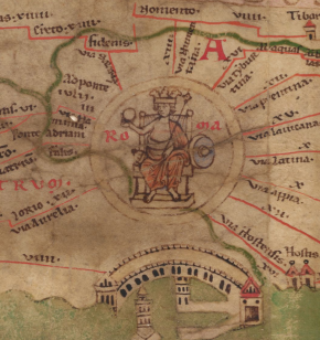
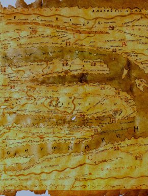
Spectacular image of a Roman map, where we can clearly see, the coding, the ability to describe the territory, the style … You can see it in the Bibliotheca Augustana.
Almost every trip involves the purchase of a map, guide or any other gadget that is used to navigate strange worlds such as cities. Items that, sooner or later, are lost by magic… Continue reading
The Human Connectome Project Navigate the brain in a way that was never before possible; fly through major brain pathways, compare essential circuits, zoom into a region to explore the cells that comprise… Continue reading
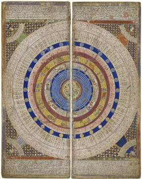
CELESTIAL MAP Author: Pardies, Ignace Gaston, 1636-1673. Date: 1693 Short Title: Plate 5: Hercules, Sagittarius and other constellations. Publisher: Sebastien Mabre-Cramoisy Publisher Location: Paris Type: Celestial Map Second edition. First edition was published… Continue reading