The Catalan Atlas
![Abraham_Cresques___Atlas_de_[...]Cresques_Abraham_btv1b52509636n_3](https://mappingworld.files.wordpress.com/2020/01/abraham_cresques___atlas_de_...cresques_abraham_btv1b52509636n_3-e1578414274391.jpeg)
The Catalan Atlas is the finest work to come from the Majorcan cartographic school of the fourteenth century. Most probably produced in 1375 (the date that appears on the perpetual calendar accompanying the maps) and attributed, though without certainty, to Abraham Cresques, the atlas was already recorded in Charles V’s library, in the inventory drawn up by Gilles Malet and copied by Jean Blanchet in 1380.
Twelve full-page paintings; pen drawing; covering paint in bright colors (blue, green, orange, mauve, golden yellow, ocher, pink, red); several patterns painted in burnished gold with color highlights, burnished silver. Filigree decorations with palmette patterns occupying the background of the circular diagrams. In the text, burnished gold letters with limited watermark decor. Red and purple inks.
Parchment; 6 double sheets of parchment, glued on five wooden boards (front and back) and on the wooden counterplates of the binding; 645 x 250 mm.
The parchment of cards alone held the boards together; it has since broken, so the cards are very damaged in the middle. Traces of water on the edge of the boards.

![Abraham_Cresques___Atlas_de_[...]Cresques_Abraham_btv1b52509636n_3](https://mappingworld.files.wordpress.com/2020/01/abraham_cresques___atlas_de_...cresques_abraham_btv1b52509636n_3-1.jpeg)

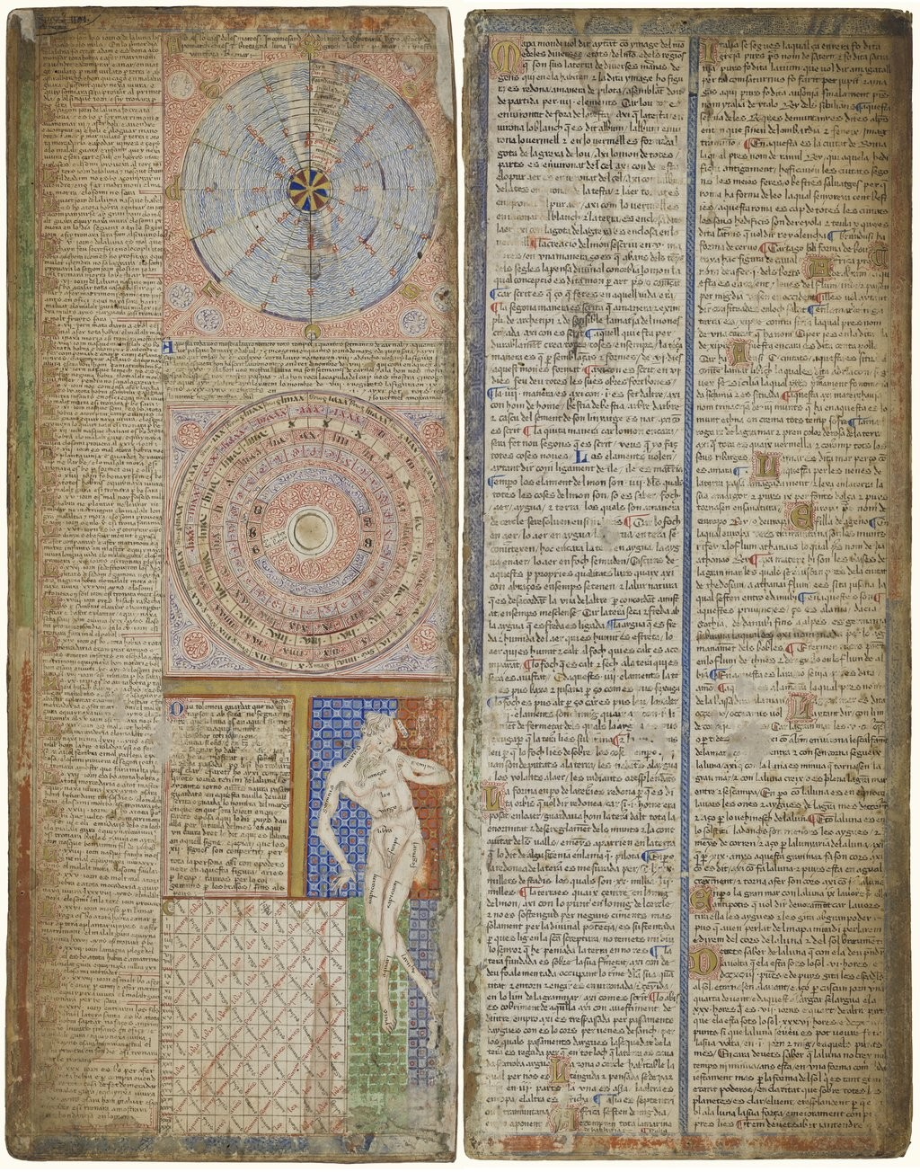
The first two leaves contain texts in Catalan covering cosmography, astronomy, and astrology. These texts are accompanied by illustrations. The texts and illustration emphasise the Earth’s spherical shape and the state of the known world. They also provide information to sailors on tides and how to tell time at night.
The four remaining leaves make up the actual map, with Jerusalem located close to the centre; two depict the Orient and the remaining two Europe and North Africa. The map is around 1.3 m2 (14 sq ft) in size. It shows illustrations of many cities—Christian cities with a cross, other cities with a dome—and with each city’s political allegiance indicated by a flag. Wavy blue vertical lines are used to symbolise oceans. Place names of important ports are transcribed in red, while others are indicated in black. The illustrations and most of the text are oriented towards the edges of the map, suggesting it was intended to be used by laying it flat and walking around it.
The oriental portion of the Catalan Atlas illustrates numerous religious references as well as a synthesis of medieval mappae mundi and the travel literature of the time, especially Marco Polo’s Book of Marvels and Mandeville’s Travels and Voyage of Sir John Mandeville. Many Indian and Chinese cities can be identified. The explanatory texts report customs described by Polo and catalogue local economic resources, real or supposed.
The Western portion is similar to contemporary portolan charts, but contains the first compass rose known to have been used on such a chart.
Source
Bibliothèque Nationale de France. Département des Manuscrits.